St Catherine's Lighthouse
-
Date of lens manufacture
1904
-
Date of lighthouse construction
1838
-
Country
United Kingdom
-
Commissioning body
Trinity House
-
Order of lens
2nd order
-
Fixed or revolving lens
Revolving
-
Active/Inactive
Active
-
Describe the character of light
Fl 5s
-
Describe the lighthouses daymarks
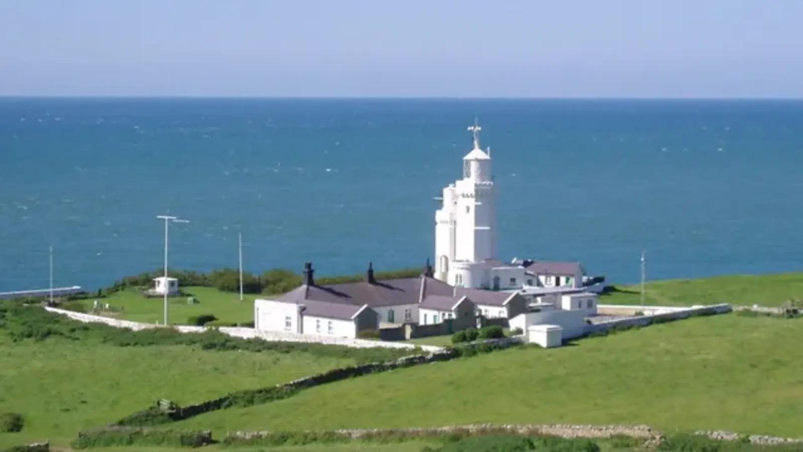
27 m (89 ft) The lighthouse was built of ashlar stone with dressed quoins and was carried up from a base plinth as a three-tier octagon, diminishing by stages. The fog signal house was eventually mounted on a lower tower annexed to the front of the lighthouse tower. The resultant effect has been to give a well-proportioned step down between the two towers which are now expressively referred to by the local inhabitants as the Cow and the Calf.
-
Which aspects of the lighthouse (other than the lens) were manufactured by Chance brothers
--- -
Describe the history of the lighthouse
The lighthouse is situated at Niton Undercliffe, five miles from Ventnor on the Isle of Wight and comprises a white octagonal tower with 94 steps up to the lantern. A fixed red subsidiary light displayed from a window seven metres below the main light and marks the Atherfield Ledge; it is visible for 17 miles in clear weather and was first exhibited in 1904.
A small light was first set up at St. Catherine's in about 1323 by Walter de Godyton; he erected a chapel and added an endowment for a priest to say Masses for his family and to exhibit lights at night to warn ships from approaching too near this dangerous coast. This arrangement continued until circa 1530 when the Reformation swept away the endowment.
The present tower was constructed in 1838 following the loss of the sailing ship Clarendon on rocks near the site of the present lighthouse. The lighthouse was built of ashlar stone with dressed quoins and was carried up from a base plinth as a three-tier octagon, diminishing by stages. The elevation of the light proved to be too high, as the lantern frequently became mist capped; in 1875 it was decided to lower the light 13 metres by taking about six metres out of the uppermost section of the tower and about seven metres out of the middle tier, which diminished its beauty somewhat.
By 1932 the fog signal house—at that time situated near the edge of the cliff—was showing substantial cracks as a result of erosion and cliff settlements; the building was eventually mounted on a lower tower annexed to the front of the lighthouse tower. The resultant effect has been to give a well-proportioned step down between the two towers which are now expressively referred to by the local inhabitants as the Cow and the Calf. The fog signal was discontinued in 1987.
A tragic incident took place at the station during the Second World War; on 1 June 1943 a bombing raid destroyed the engine house killing the three keepers on duty who had taken shelter in the building. RT Grenfell, C Tomkins and WE Jones were buried in the local cemetery at Niton village and a plaque in remembrance of them is displayed on the ground floor of the main tower.
St. Catherine’s Lighthouse was automated in 1997 with the keepers leaving the lighthouse on 30 July.
The lighthouse had been a weather reporting station for the Meteorological Office for some years; the keepers made hourly reports which included the temperature, humidity, cloud height and formation and wind direction and force. Following demanning of the lighthouse an automatic weather reporting station was installed which sends details of the weather conditions to the Met. Office.
-
Current management body/ ports authority
The lighthouse is now monitored and controlled from Trinity House’s Planning Centre in Harwich, Essex.
-
Historical preservation societies/manager/operator
Trinity House’s Planning Centre in Harwich, Essex.
-
Is the site vulnerable to coastal erosion?
yes -
Have you experienced any affects of climate change on the lighthouse?
--- -
Observations on the condition of the lighthouse?
--- -
Is the site open/closed to the public
Open
-
Is the tower open/closed to the public
Closed
-
Latitude and Longitude
Site is open 50°34′33″N 1°17′52″W
-
On-site bookable accommodation available
yes -
Associated web addresses
- https://www.trinityhouse.co.uk/lighthouses-and-lightvessels/st-catherines-lighthouse
- http://www.isleofwightattractions.co.uk/StCatherinesLighthouse.htm
- https://www.nationaltrust.org.uk/st-catherines-down-and-knowles-farm/features/history-of-the-lighthouse-at-st-catherines-point
- https://historicengland.org.uk/listing/the-list/list-entry/1209275?section=official-list-entry
- https://onthewight.com/st-catherines-lighthouse-closes-its-doors-to-visitors/
- https://www.ibiblio.org/lighthouse/engs.htm
-
Other details
The lighthouse used to be open to the public but has since closed. Cottages were available to stay in.
ARLHS ENG-143; Admiralty A0774; NGA 1064.
-
Which resources did you use to research this lighthouses?
---
Where?